The majority of tier one contractors in Britain have deployed the innovative 3D scanning system Matterport, explain Charles Hill and Karl Pallas, co-directors of Immerse UK, a local reseller for the system.
What is Matterport?
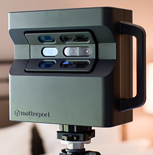
CH A camera device that records light and depth data to quickly generate an accurate photo-realistic 3D model of a space. The scans are created by moving the device to successive positions around a building, each scan rotation takes around 30 seconds.
The raw scan data is uploaded to the cloud to quickly generate a complete dimensionally accurate 3D model, which can either be downloaded as a point cloud file (the same output as laser scanner) as a coloured texture map mesh file or viewed in a web browser.
Who is using it and how?
CH Basically every tier one has it – it’s being used on the King’s Cross redevelopment, on Thames Tideway, and on the Northern Line extension.
The BAM Ferrovial Kier joint venture is using it on the Farringdon Crossrail station to create a an accurate record of work before trades hand-off.
For example, a scan might be carried out when the block layers finish before the first fix electrical guys come in. The files are time and date stamped and it’s possible to add tags to the 3D space that link back to the document control system to highlight any outstanding RFIs.
Sending a person out daily to capture a space and share it with subcontractors removes the need to take lots of photos and the potential for a dispute.
What are the benefits?
KP Unlike laser scanners that require a skilled engineer, anyone can use a Matterport device. Onsite capture is much faster, the system auto-aligns itself and works out the floor level, so there is no need to set out targets.
Anyone can use a Matterport device
When you get back to the office you don’t have to stitch 100 scan points to a floor plan or a CAD file, you simply click the upload button and within a couple of hours you have a fully-rendered model.
CH Compared to photogrammetry, it is faster, cheaper and provides a better-quality end result. Compared to laser scanning it is faster and substantially cheaper, but not as dimensionally accurate. If millimetre precision isn’t a requirement, which it often isn’t, this is the best option.
KP Most customers say it’s an amazing communication tool. Rather than have to take a trip to head office to do an hour-long progress report then drive back to site, they can simply share the link and do a phone call.
Can it be deployed at different stages of a project?
KP Yes, we have people using it pre-construction to scan existing spaces and use the models to inform the tender. When things move into the design phase people can import the 3D data, point could etc, into regular design software like Autodesk Revit to start working up ideas.
During construction, projects scan prefabricated units before they arrive to site, adding in information tags or links to video to explain the installation process to operatives on site.
Some sites are using the models for health & safety inductions to highlight the work going on that day and the big risks.
At handover, scans can provide the client with a reliable record of what was built to use as the basis for any claims or defect reporting.
How does the technology work?
The scanner fires out infrared grids over surfaces, the received dimensional depth data is stitched together with light patterns and images in a process called structured light.
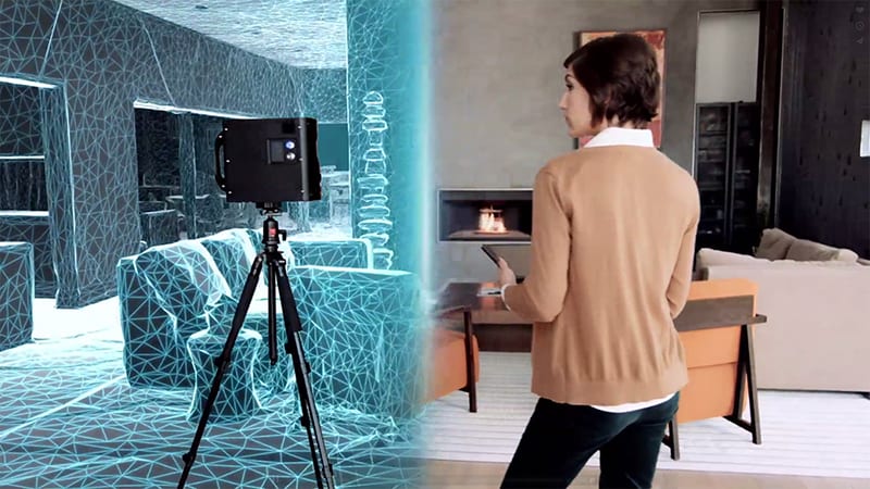
The scanning process is based on motion sensor technology used in the Kinect device for the XBox games console.
When the camera is moved around a space is must to be able to identify where it was positioned for the previous scan, which enables it to recognise the geometry and automatically align itself. The process is based on motion sensor technology used in the Kinect device for the XBox games console.
What does it cost?
One Matterport camera costs £3,295 plus VAT. We sell a lot to traditional surveying companies who use it as a supplement to their LIDAR activities to get fast and clearer immersive images.
How will the technology develop?
KP Matterport is used extensively in the real estate sector to create Google Streetmap-style click to navigate 3D models of property interiors. It currently hosts more geospatial data on its web servers than any other organisation in the world, covering over 650,000 3D models.
There are plans to start using artificial intelligence to interpret and organise that data. It might be possible to categorise rooms by recognising certain standard objects, or carry out inventory checks of completed buildings, for example automatically counting the number of desks in an office.
In construction it may be possible to compare 3D CAD or BIM models with Matterport models to automatically identify where changes from the original design have occurred, rather than spend money on a professional engineer to do as-built drawings. All of these technologies are possible today, it’s just a matter of testing and trialling them.
A scan might be carried out when the block layers finish before the first fix electrical guys come in. The files are time and date stamped and it’s possible to add tags to the 3D space that link back to the document control system to highlight any outstanding RFIs.– Charles Hill, Immerse UK