As the Ordnance Survey launches CAD-ready 3D mapping that is compatible with Autodesk InfraWorks 360, Gary McDonald, OS strategic relationship manager, explains to BIM+ the tool’s applications and how it functions.
What are the main applications of the tool?
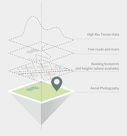
OS Model Builder is the result of a collaboration between Cadline and Ordnance Survey (OS) to provide Autodesk Infraworks 360 customers with a single source of Great Britain’s most accurate and up-to-date collection of geographic data.
All the maps are presented in a pre-configured CAD-ready file that can be used to create 2D and 3D building or infrastructure models in minutes rather than days or weeks. The application is available over the web, runs on any device and can be trialled for free.
The tool has many powerful implications for the industry:
- It can help evaluate the risks and costs of projects from your desk, eliminating time-consuming and costly travel to numerous sites.
- It can improve the speed of informed decision making.
- It can provide clients with stunning visual representations, helping them easily understand the various aspects of a project while at the same time increasing their customer care and keeping the project delivery team and the supply chain focused throughout the lifespan of a project by using the same visuals and data as the goal to work towards.
How does the tool interface with a BIM model?
The app provides an amalgamated data model, using OS MasterMap, Terrain 5 and aerial imagery, which can then be downloaded into Autodesk Infraworks. From Infraworks the user can collate data sets and 3D models from other parties or from their own organisation to build up a more comprehensive model of the area of interest.
Infraworks allows easy model collaboration with its compatibility to import/export from Autodesk Revit, Navisworks and Autodesk AutoCAD Civils 3D, as well as many other formats. The OS Model Builder, therefore, makes it easy and cost-effective to model the environment at early design or bid phases, and then collaborate internally and externally with the same data source further down the design stages.
Is the tool compatible with all types of software?
The OS Model Builder is a standalone web-based application. However, it currently will only provide models for download into Autodesk Infraworks. The product roadmap will consider additional download options dependent on user demand. Once the model resides in an Autodesk Infraworks environment, it can then be exported into many software formats, eg FBX.
What advantages does the tool offer compared to working with traditional mapping?
OS Model Builder uses a range of accurate datasets. These include OS MasterMap Topography Layer, aerial imagery, 3D terrain data, 3D building data and datasets showing road and river networks. The system also allows users to bring in additional third party data to enhance the visualisation of the project.
How accurate is the tool?
The data has been compiled from a number of OS datasets with various accuracies depending on the source scale, but not millimetre accuracy – and it doesn’t need to be for the intended usage. However, the data is certainly much more accurate than the data that is available on other similar systems. For example, the OS MasterMap topography layer building outlines (which are used in the models), are captured in urban areas to 40cm.