A new camera innovation from Leica that combines image capture with 3D laser mapping, is being used for the first time to capture UK cities in amazing detail.
Bluesky International has used the Leica CityMapper, the world’s first hybrid airborne sensor combining vertical and oblique imagery with 3D laser scanning, to capture major cities throughout the UK.
Using the CityMapper, Bluesky has mapped parts of London, Manchester and Birmingham as well as Brighton, Bristol, Cambridge, Norwich, Nottingham and Oxford. It intends to increase its coverage by capturing additional towns and cities across the UK and Ireland in 2019.
It is the first time this technology has been used commercially in the UK to this level. The captured city data is currently available from Bluesky and Leica Geosystems, part of Hexagon, in its constituent components of vertical orthorectified aerial imagery, oblique photographs and LiDAR point cloud data. Plans are in place to also include the imagery in Hexagon’s HxGN Content Program in the near future.
“The combination of multiple survey grade cameras and LiDAR enables, for the first time, the simultaneous capture of data for the automatic creation of highly accurate and detailed citywide 3D models, with one sensor,” said Rachel Tidmarsh, managing director of Bluesky.
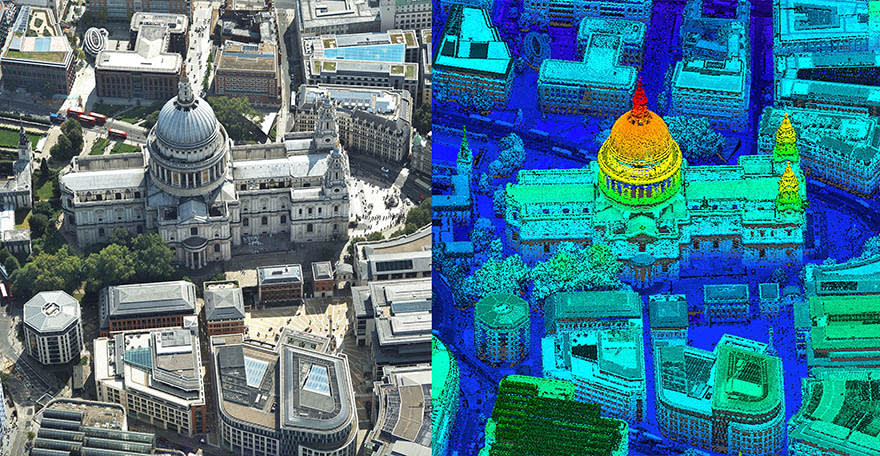
CityMapper has been used to capture parts of London, including St Paul’s cathedral
“Whilst 3D models have been around for a number of years, they have either been prohibitively expensive for use across larger areas or of insufficient detail or accuracy. Using the CityMapper sensor, we can achieve efficient, and therefore cost effective, capture of highly detailed and accurate data, making widespread use of 3D models a reality.”
CItyMapper includes a traditional vertical camera as well as survey-grade oblique cameras. Specially designed for 3D city modelling and urban mapping, the sensor also includes high performance LiDAR technology to accurately collect elevation data even into the shadows, which are common in urban environments and make photo-based data collection difficult.
The CityMapper sensor also collects colour infrared data, which can be used to aid greenspace mapping and vegetation studies.
Applications of the new Bluesky 3D models are expected to include urban planning, line of sight analysis, new development visualisations and environmental modelling, as well as potentially 3D fly throughs and virtual reality experiences. Early adopters of the data include architects, planning consultants and other map publishers.
“The CityMapper was designed for just this type of use – capturing the many layers of urban environments,” said Ron Roth, Leica Geosystems’ geospatial content solutions product manager of airborne topographic LiDAR. “We are excited to see the high-quality data Bluesky has been able to produce with CityMapper, and we are sure many customers will benefit from this capture.”
For more information about Bluesky, please visit https://www.bluesky-world.com/