Ian Tansey, managing director of ProDroneWorx, explains how the digital outputs from drone technology are being used for planning, maintenance, inspection, management and surveying of assets.
Drone technology, cameras and data processing have come a long way over the last few years and are now a creditable alternative to the traditional ways of assessing assets by building surveyors or facilities management firms. RICS recently published a report on this subject for its members highlighting some of the benefits.
The technology can be used to gather digital asset data for pre-acquisition surveys, due diligence surveys, planned maintenance programmes, dilapidation surveys or schedule of conditions. The digital data provides deeper data insights, better collaboration on projects, improves data deliverables to clients, while reducing costs and risks.
Drone technology can be used for different types of asset/portfolio surveys, for example residential, commercial or industrial roof, facade or building inspections. The digital outputs from drone technology can be as simple as geo-tagged HD images or video, to more complex outputs like a 3D point cloud, 3D textured model, 2.5D digital surface model (DSM), 2D orthomosaic or 2D Google KMZ files.
The digital data can also be used to create 2D CAD drawings of roof structures when traditional methods cannot get access to the roof structure due to H&S issues.
Drone technology is a value-adding tool for most asset/portfolio inspections as it is safe, quick, economical and there is no business disruption. The digital data produced can be used by the surveyor as part of their assessment on the condition of the asset.
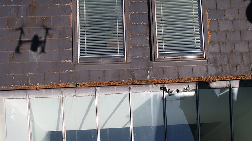
Drone technology can be used for surveys of residential, commercial or industrial roof, facade or building inspections
Some companies are starting to look at how they manage the digital outputs from a drone inspection as a large amount of information can be captured and sent to the surveyor for analysis.
A cloud-based platform can be used to store, manage, share and analyse the digital data. This allows multiple users within a company to analyse the data, include annotations and then produce a PDF and/or Excel report based on all the defects/issues that were identified. This information can be shared with contractors for pricing repairs or maintenance.
Managing asset inspection data digitally has many benefits:
- Improves team collaboration and workflow on projects
- A digital record of an inspection in time
- Gives the ability to compare inspection data over multiple time periods
- Data can be digitally shared with contractors for pricing of works
- Communicate with the client on works to be carried out
Drone technology can be used for asset inspections in congested cities such as London or Birmingham to more rural or less congested areas. It is important to engage a drone operator with the right skills, equipment, insurance and importantly a CAA license to carry out the operation.
A small percentage of operators in the UK have a special license from the CAA called an OSC (Operational Safety Case) which allows them to carry out complex drone operations in heavily congested (urban) areas.
When operating in London and other big cities it is not unusual to have to seek permission from national air traffic services, Met Police and the Diplomatic Protection Group (DPG) to carry out an asset inspection.