


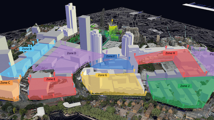
A digital replica of the 21 ha Canada Water site in south-east London has been mapped for British Land by Sensat, the visualisation and collaboration software company for civil infrastructure.
Embarking on a £4bn project to redevelop Canada Water, British Land is developing a new town centre for Southwark Council. As part of the Canada Water Masterplan, British Land selected information management firm for the built environment Amodal and Sensat to provide a complete overview of the entire site, enabling multiple teams and project stakeholders to visualise site conditions without having to be on site, supporting project decision-making, contingency planning and frictionless collaboration.
“The ability to both accurately scan the site, and confidently pull together lots of disparate data into one single platform, is amazingly powerful. The speed of iteration really helps for quicker options appraisal, more efficient handover processes, and better clash detection to reduce contingency costs. It’s been an invaluable resource when thinking through phasing,” said David Walters, programme director at British Land.
“Organising all historical and current project information into a CVE takes having an oversight of the multiple data layers that make up a project up to a new visual level.”
“Adopting a common visualisation environment (CVE), such as Sensat’s, enhances our visualisation capability and has proven instrumental when it comes to data validation. By scanning the site using drones, and displaying this highly-accurate data in Sensat’s platform, we have been able to establish disparities between the actual locations of assets and their previously documented locations. Spotting problems early, ahead of the design phase, means we can significantly reduce the level of risk contingency costs, which could easily be into the millions.”
Amodal was commissioned by British Land to help it translate the complexity of the project and all its building information and processes into the digital world to continually evolve and identify efficiencies throughout the lifecycle of the project.
“Organising all historical and current project information into a CVE takes having an oversight of the multiple data layers that make up a project up to a new visual level,” said Thomas Whiting, MD at Amodal. “Sensat was able to complement the data sets used on British Land’s existing software to enhance the visualisation and user functionality of current (and future) data sets, providing a seamless transition from an existing common data environment to CVE. This golden thread of information is allowing for better stakeholder engagement, collaboration, and integration across teams.”
James Dean, CEO of Sensat, said: “Being part of one of the largest mixed-use regeneration projects in London has demonstrated how bringing all the right information together can really change the dynamic of a project for the better. A masterplan of this cost and scale could easily become fragmented, falling foul of misaligned incentives, behaviours and objectives, as well as delayed delivery timetables due to unreliable data, but we have helped overcome this and accelerate planning.
“It’s only when you see comprehensive information on existing assets, above- and below-ground utilities and infrastructure, as well as surveys and inspections, visually in one place that you can support collective problem-solving and mitigate the risks.”


