


Network Rail has been working with Atkins’ digital team to keep vegetation off the rails, reducing the need for the workforce to undertake on-foot inspections in the hazardous live railway environment. Denise Chevin reports.
Atkins’ applied technology practice is a centre of excellence for data, digital and technology skills that works on solving complex client challenges across a range of critical national infrastructure.
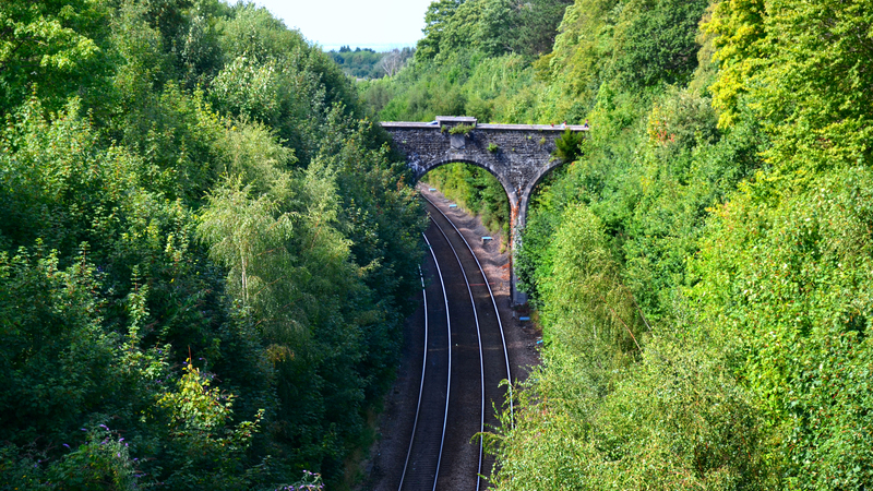
One area of particular interest to government, rail operators and passengers alike, is Atkins’ work on digital lineside inspection in the rail industry. Traditionally, this has been an arduous manual process, with Network Rail staff undertaking inspections, looking for encroachment by trees and undergrowth onto the railway network.
It’s vital work, with safety of passengers and staff at the heart of it. But with responsibility for 10 million trees across 20,000 miles of rail tracks, the task is enormous, and despite best efforts, disruptions still occur regularly to many of the 1.7 billion rail journeys that take place each year. The bill for clearing lines, compensating passengers and repairing damage to infrastructure and rolling stock has been costing Network Rail more than £100m a year.
Little surprise then that Network Rail’s principal lineside engineer wanted to take a new approach. Could engineers understand the condition of the vegetation with less need for the workforce to undertake on-foot inspections in the hazardous live railway environment?
How to approach the problem
Atkins was commissioned to explore the possibilities and a proof of concept (PoC) was designed. This included the creation of a new intelligent vegetation management tool to:
- help proactively manage trackside vegetation;
- improve safety of the workforce and the passenger; and
- comply with reporting requirements of the Office of Rail and Road.

“Our work went straight to the digital lineside inspection decision support tool software team and Network Rail is now able to look at each section of their network, to clearly understand the extent of works required.”
Leading the Atkins delivery team was Jenny Wells, senior GIS consultant. She explains: “To kick things off, Network Rail partnered with an Atkins delivery team, with myself as the lead geospatial analyst, to determine if pre-existing data could be used to identify and accurately assess risk of vegetation encroachment, and to translate Network Rail’s standards into a compatible digital model to analyse and act on the findings.”
Using LiDAR-flown laser technology, Network Rail already plots the surface of the Earth along its rail routes, accurate to within a centimetre, creating mass point cloud datasets. Since 2014, it has held extensive aerial survey LiDAR data for the whole network.
Wells says: “Network Rail was keen to collate all the information it held from different data sources to create a single point of truth. This would then allow for a reduced need for on-foot inspections and the effective allocation of resources to address any identified issues of vegetation encroachment.”
The way forward
Based on this, the Atkins team agreed two objectives: first, to determine if pre-existing data could be used to identify and assess the risk of encroaching vegetation; and second, to translate Network Rail’s standards into a digital model and algorithm that could be used to inform their management and operations strategy and support regulatory compliance.
Wells explains: “My colleagues and I began by holding a series of workshops with senior stakeholders from across Network Rail. We needed to capture facts, opinions and aspirations from people with different areas of expertise – engineers, developers, operations teams – to ensure we created the right objectives. Next, we created a blended delivery team with Network Rail.”
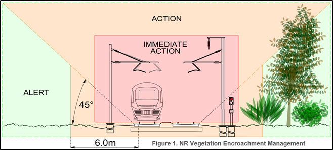
Network Rail’s existing vegetation management standard classifies vegetation into one of three categories, as shown in the image below. According to the specification, there should be no vegetation at all in the red immediate action zone; an action plan should be in place for vegetation in the amber action zone; and a need to ‘be alert’ to any vegetation in the green alert zone.
Digital mapping
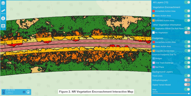
The geospatial team used the Feature Manipulation Engine (FME) software – a data integration platform – to create a 3D representation of the encroachment zones around the areas of track being tested.
“To start with, we used a small 5km section of track to provide early insights and demonstrate clearly the benefits of the project,” Wells explains.
The LiDAR data provided had exact height information for every point scanned, creating a point cloud that was post-processed to indicate features such as ground, track, buildings and vegetation. FME was then used to create bespoke vegetation elevation models from the classified point cloud. The vegetation elevation model was intersected with the encroachment zones to identify the locations, severity and magnitude of vegetation encroachment with respect to the existing Network Rail standards.
The 5km trial proved a success and the next challenge was providing the results in a visual format.
Wells explains: “We solved this by using Atkins’ digital twin survey platform, Cirrus Insite, customising the web interface for early benefit realisation. The platform provided the resulting findings both visually, in an interactive map and numerically in terms of area (sq m) to enable the best possible understanding.”
This unprecedented approach used a complex interplay of 2D and 3D geometric techniques to produce a method totally new in the railway industry, creating immediately actionable results in a clear visualisation. By leveraging geometries within existing spatial data, the costly need to collect additional data was removed, enabling the PoC to move directly into production within a very short timeframe.
Excited by the results, Network Rail decided to move the project from the R&D phase into prototype, with a plan for a phased roll-out soon after.
“Network Rail was given the FME workbenches and extensive usable documentation, so they could replicate the same process for other sections of the track,” says Wells. “Our work went straight to the digital lineside inspection decision support tool software team and Network Rail is now able to look at each section of their network, to clearly understand the extent of works required and enabling them to create a detailed management plan before sending people out onto the network.”
Journey’s end
Atkins’ work has contributed to an 80% reduction in on-foot inspections and savings of tens of millions of pounds a year.
Alan Cooke, Network Rail principal engineer [lineside], is impressed: “What excites me most about this work is the intelligence applied to the dynamic baselining. This model will be the cornerstone of a number of future digitised lineside inspection applications.”
Network Rail is now carrying out a new aerial survey of the whole rail network as part of its Intelligent Infrastructure Programme. The data from this and potential future surveys will be compatible with the new tools, helping to keep Britain’s railways clear of vegetation. Passengers will be just as delighted as Network Rail and train operators.
Comments
Comments are closed.


Excellent use of digital technology to provide a solution to what seems a very basic but costly maintenance problem.