


Earth observation company 4 Earth Intelligence has used satellites to create the UK’s first street level map of “at-risk” areas to help plan for and manage the effects of extreme weather conditions.
With support from the Ordnance Survey, the Heat Hazard Postcode data is being made available free at the point of use to national organisations and multi-agency partnerships, such as Local Resilience Forums, that are currently battling the coronavirus pandemic.
Derived from satellite imagery and created using automated algorithms, the data identifies hot spots within urban areas where temperatures are generally higher, forming an “urban heat island”. With the summer of 2020 already being predicted as one of the hottest on record, it is feared that this could severely impact on already stretched public resources. It is estimated that the heatwaves of 2019 led to almost 900 extra deaths in England and if the lockdown remains, it is possible the figures for 2020 could be higher.
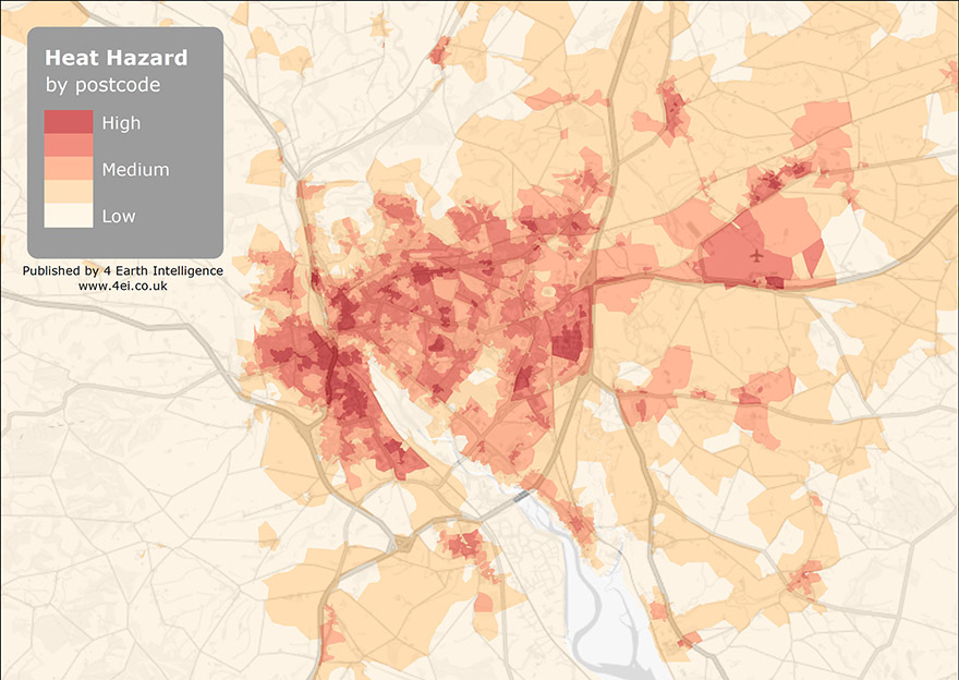
The data identifies hot spots within urban areas where temperatures are generally higher
Increased daytime temperatures, reduced night-time cooling, and higher air pollution levels associated with urban areas can affect human health by contributing to general discomfort, respiratory difficulties, heat cramps and exhaustion. These conditions can also cause non-fatal heat stroke and heat-related mortality.
Richard Flemmings, CTO and co-founder of 4EI, said: “Even during normal conditions extreme weather events can result in significantly higher numbers of deaths, especially among people over 65 and those with underlying health conditions – the same group that are more at risk of Covid-19 and are being asked to self-isolate.
“By providing Category 1 responders with intelligence derived from past events we hope that this will help plan for and mitigate against the worst scenario. This information can be used to target vulnerable households with information about coping strategies and signpost supporting organisations or emergency responders.”
An Urban Heat Island or UHI is a metropolitan area that is warmer than the surrounding areas. Research funded by the Department of Health in the UK indicates that over 7,000 people could die from the effects of urban heat waves per year by the 2050s.
The 4EI Heat Hazard data will be supplied as CSV files for use in spreadsheets so that end users not used to working with geospatial data can easily access the data and will be available for use until the end of September 2020.
Comments
Comments are closed.


How about heat loss from the entire building stock