


Tobias Heller, senior product manager at Leica Geosystems, outlines the advances in the latest 3D scanning and imaging technology and how they are impacting construction and architectural professionals.

By combining measurement sensors, software and on-device edge data processing, the BLK3D enables in-picture measurements with professional-grade accuracy. Every image it captures is a complete and precise 3D record for BIM.– Tobias Heller, Leica Geosystems
Accurate measurements represent an important asset for a variety of professions, even though traditionally associated with architecture, engineering and construction (AEC).
Upon re-examination of the purpose of highly accurate information it becomes obvious that there are still many industries that are both unfamiliar and in desperate need of tools that allow them to optimise their workflows.
Businesses that integrate BIM can testify to its advantages, which range from improved project timelines to substantial cost savings. In this context, technology must not only continue to support these existing expectations and value but also aim to tap into undiscovered potential and take the process to the next level.
Entirely new projects, regardless of the industry they sit within, require collaboration and connected devices to guarantee best results. By introducing accessible technology that allows us to share plans, accurate measurements and other assets in real-time, the possibilities of application are near endless.
The BLK series, from Leica Geosystems, is an example of how widening the focus to many industries is shaping the way today’s technology is conceived and developed. The Leica BLK360 imaging laser scanner and the Leica BLK3D handheld imager are both reaching and transforming the work of new markets by placing reality capture and millimetre-accurate measurements in the hands of new groups of individuals.
These include real estate agents, property consultants, experiential designers, forensic specialists and public safety officers, alongside architects, engineers and construction workers.
What’s more, with these devices in hand the requirement for specialist training or skills is a thing of the past as they are designed specifically to be used by those without any reality capture expertise. Simplicity in design and in use are in fact enabling the democratisation of previously exclusive and unimaginable technologies.
Measurements at your fingertips
By combining measurement sensors, software and on-device edge data processing, the BLK3D enables in-picture measurements with professional-grade accuracy. Every image it captures is a complete and precise 3D record for BIM.
This allows anyone who has a need to measure or document a space to simply take a photograph and produce a digital record of its evolution, tracking its precise measurements and even attaching it to a floorplan for future reference.
Furthermore, the device’s edge capabilities eliminate the need for network connections or cloud services, ensuring professionals can make faster decisions within their daily workflow. Whether it is creating floorplans and estimating building installations, or documenting construction progress and creating as-built facility documentation, the BLK3D will connect seamlessly to a computer where data is automatically synced and measurable images can be accessed, processed and organised.
With the expanded functionality of the desktop software, users are also able to create new projects and CAD-ready 3D models from their images.
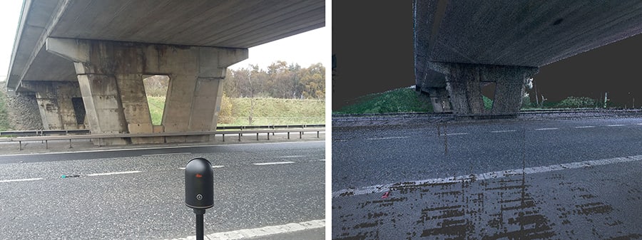
Leica’s BLK360 created accurate 3D point clouds and images for Amey Roads NI
Reality capture for everyone
As with the BLK3D, the BLK360 has been disrupting the industry since its launch in 2016 by enabling new sectors to capture 360-degree HDR spherical imagery and point cloud data within minutes.
This miniaturised 3D imaging laser scanner has also contributed towards lowering the barrier of entry to laser scanning and continues to represent an accessible tool for professionals who are beginning to explore BIM and reality capture for the first time.
An example of this is the work developed by Amey Roads NI (ARNI) on its recent project to build, operate and deliver improvements to a strategic road network across Northern Ireland, for which it turned to the BLK360 to create accurate 3D point clouds and images.
“Gone are the days of hand written notes and zoomed-in photographs that no one can figure what part of the structure we’re looking at,” says John Jordan, ARNI’s lifecycle project manager. “The BLK360 has already proven itself as an integral part of our team, and we look forward to continually exploring the possibilities of the technology and identifying new ways it can transform our work, create efficiencies and reduce costs.”
As we move forward, the concept of “democratisation” must continue to have a presence and crucial role in the process of conceiving and developing new technology solutions.
Providing accurate measurements, whilst measuring up to new expectations and the needs of professionals, is ultimately the best way to guarantee a bright future for BIM, pushing its boundaries and allowing new use cases to be explored across the globe.


