


Australia-based tech start-up Sitesee uses 3D reality capture and automated object recognition to remotely monitor the condition of infrastructure. CEO and co-founder Lucio Piccoli tells Stephen Cousins about the benefits and challenges.
What service does Sitesee offer?
We send up drones to capture a 3D reality model of large infrastructure assets, which owner/operator clients use to perform condition assessments remotely via a browser on their desktop.
The software offers features you would expect from many 3D viewers: access control, on-the-fly measurements, and an array of visualisation tools etc.

Lucio Piccoli: no limit to what can be achieved
In addition, sophisticated machine learning capabilities make it possible to automate condition assessment reports, using object recognition to instantly recognise and categorise different components that need to be assessed or maintained.
What are the advantages of object recognition?
Telecoms tower owners want to ensure they are being billed correctly for equipment on the tower and ensure as-built matches the as-designed.
Our clients might have as many as 50,000 towers scattered across the country, and the need to carry out an annual audit of each one makes our solution the only one that is both accurate and scalable. Manual inspections are more costly and time consuming, as a result an audit might be done every two to five years.
What types of equipment can it recognise?
The make, model and height of antennae, it can analyse the current condition of the tower and any damages or inconsistencies. It can learn to recognise most of what the client needs to know about the structure’s current state.
Is it only telecoms infrastructure you are able to inspect in this way?
Telecoms is using the most sophisticated automated object recognition. We have developed solutions for oil and gas infrastructure, able to automatically identify prefabricated components in piping systems, but the industry doesn’t yet seem ready to use this.
Could the process be applied to buildings, for example used by facilities managers to monitor the external condition of large estates?
Possibly, in my experience it has been difficult to pin down an effective value proposition for object recognition. It can work with infrastructure that is large, complex, remote and dangerous to people. Our solution requires a clear business problem from the client that needs to be solved.
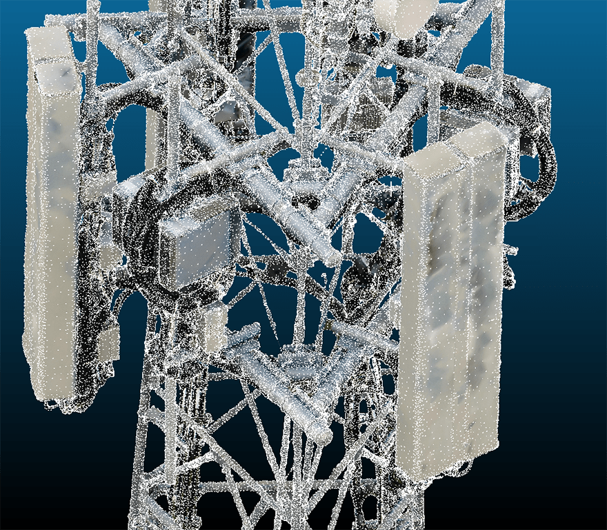
A point cloud created from data collected by drones
How is the technology advancing?
There are two truths in our world: 1) SiteSee object recognition is not perfect. 2) There are new shapes of equipment being deployed on a regular basis.
To solve these issues we enable expert end users to manually annotate models and reclassify objects correctly. This data is then fed back into the system to continuously improve the machine learning.
Is 3D data captured by drones in the field always high quality?
The drones and sensors for the GPS and camera are fantastic, but using humans to pilot UAVs introduces too much variability and limits truly vast scale out.
We are working with two fully autonomous drone vendors to produce continuously deployed fully-autonomous drone capture. This will allow drones to stay in the field and capture when required with little or no human interaction.
Will we ever reach a stage when the condition of all external components on an asset can be monitored remotely in this way?
Certainly, if there is a need there is no limit to what can be achieved. As long as there is a business benefit that can be exploit with this technology. It is surprisingly difficult to produce a value-based proposition using automated object recognition.


