ISG, BCM Construction and consultancy Blackburn & Co have deployed a cutting-edge artificial intelligence system designed to rapidly capture projects and transform them into navigable Google Street View-style walkthroughs.
The system, from San Francisco-based startup OpenSpace, is backed by co-working giant WeWork and uses a standard 360-degree camera attached to a hardhat that passively records images as a builder walks the site carrying out their duties.
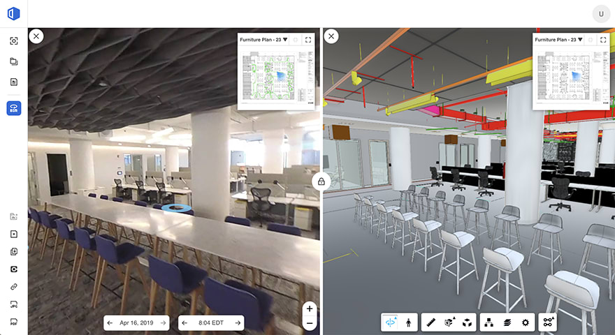
The image data is uploaded to the cloud, where algorithms automatically map the photos to project plans and “stitch” them together to create an accurate visual representation of the site without any human intervention.
The data accumulates over time to give construction professionals the ability to review site conditions over previous days, weeks or months. This can be harnessed to improve coordination between project stakeholders, resolve disputes, clarify RFIs and change orders, as well as creating a historical record of construction for future renovation projects.
The key benefit of the technology over existing approaches is speed and quantity of data capture, says Jeevan Kalanithi, co-founder and CEO of OpenSpace: “We make it much easier to do more frequent and more complete site capture. Traditionally, a builder has to snap photos of the entire job site, then sort, organise, and label those photos once they are uploaded.
The key benefit of the technology over existing approaches is claimed to be speed and quantity of data capture
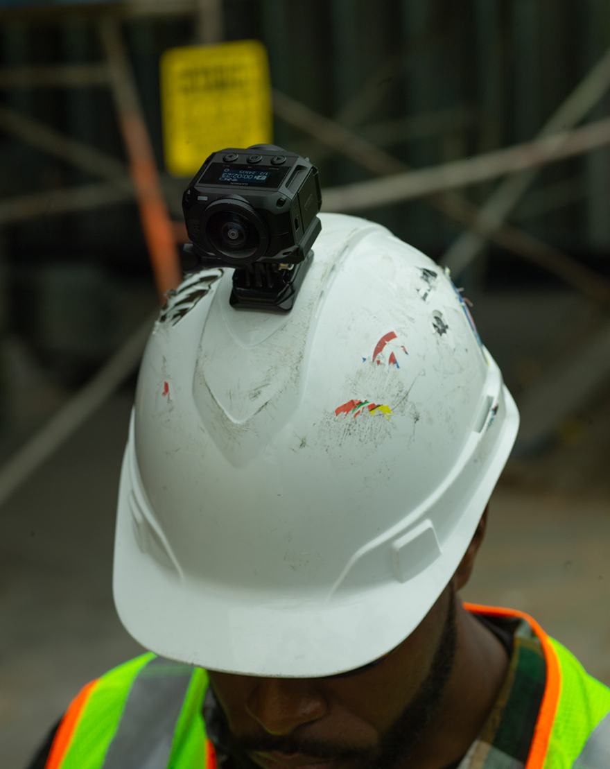
“It’s a time-consuming and tedious process, which means that site documentation isn’t done as often as it ideally would be. OpenSpace automates this entire process: a builder simply attaches a small 360-degree camera to their hardhat and walks the job site.”
OpenSpace received a US$14m (£10.9m) capital injection over the summer from investors including WeWork, contractor Suffolk Construction and real estate developer Tishman Speyer. The financing follows an initial US$3.5m (£2.7m) seed round at the company’s inception in September 2017.
Suffolk has used the platform for more than a year after piloting it on a project in upstate New York. In an interview on the website Constructiondive.com, chief data officer Jit Kee Chin says the most compelling feature is automatic tagging of images to floor plans, which simplifies navigation. Suffolk managers used the software to share updates with the client, who was based in New York City and unable to visit the site in person.
OpenSpace can integrate with BIM platforms, including construction management software Procore and Autodesk BIM 360. Both allow customers to directly access OpenSpace site images within the applications to simplify processes like RFI generation. In addition, it is possible to align the jobsite photos with Navisworks and Revit models to create side-by-side “photo-to-BIM” comparisons.
Other proprietary site scanning technologies, such as Matterport and the NavVis M6 trolley, are designed to deliver quick data capture and generate click-through panoramas, but Kalanithi claims they can’t match the speed of OpenSpace.
“Navvis and Matterport are great for periodic captures, but they can’t compete with OpenSpace for daily capture. Plus, images are much more intuitive and accessible for everyday collaboration and review tasks,” he says.
According to Kalanithi, one of the biggest technical challenges the technology solves is the ability to provide location assurance in environments without GPS coverage. “We are able to orient photos relative to the correct location on a floorplan, without any GPS metadata telling us where the image was taken,” he concludes.