When the average cost of a mega-project runs to ten figures, any minor hitch can have significant cost impact. Ground deformation can have an impact not only during construction but also afterwards in the operation phase. SatSense provides precise and up-to-date deformation monitoring services using data from satellite radar. Here, Tom Ingleby, Earth observation specialist at SatSense, discusses the technology.
Significant, unforeseen ground movement within an infrastructure project can cause serious structural damage, the cost of which can run into millions to repair and potentially delay a project by months. Network Rail has suggested that geotechnical risks associated with cost and time over-runs might occur in 20% to 50% of projects. These movements can occur for a multitude of reasons: ground settlement, groundwater movement, historic mining sites, inadequate design or poor construction of foundations.
Downward movement (subsidence) rarely happens instantaneously: it is more often a slow process, where ground movements occur over a longer period of time, typically months or years. Geotechnical engineers generally research and/or monitor sites before a build begins to assess the level of risk associated with the location and determine any possible adverse consequences. However, historical data can be hard to get hold of, and obtaining data during and after construction can be costly.
Subsidence monitoring
The InSAR technique is increasingly being used by geotechnical engineers as a remote sensing technique for assessing and monitoring movement over areas from specific locations (a property) through to entire networks. Subsidence can be measured using historic satellite radar data covering previous decades, and then monitored throughout the duration of a project and beyond.
InSAR stands for interferometric synthetic aperture radar and is a highly effective way of measuring changes in land surface altitude. Imagery is produced by illuminating a target area using radar and recording the reflected signal. This means the technique can work in any weather conditions, night or day. It is an accurate way of detecting ground movements and can be scaled from single pixels (typically 3m x 3m or 4m x 14m) to entire countries.

Subsidence rarely happens instantaneously: it is more often a slow process, where ground movements occur over a longer period of time, typically months or years.– Tom Ingleby, SatSense
Innovative technology companies are able to analyse InSAR data to create insight into the risk of ground movement in their chosen location. The time series of data can be automatically assessed for thresholds of acceleration, range, absolute movement and more being exceeded.
Having access to this data means engineers and project managers can identify potential issues on a project and take action before significant damage, costs or delays are incurred. The use of satellite data also means information is readily available. No trips to site are required. Data can be pre-processed, so engineers have quick or instant delivery of the information, and timely alerts to any notable changes – meaning desk studies can be completed quicker and more cost-effectively, and action can be taken sooner rather than later.
This data is not only valuable during the construction phase: all mega-projects are monitored in some form during their operational phase to ensure they remain in good order, do not develop catastrophic structural problems, and maintain public safety. Continuous monitoring using InSAR can be used once the structure is in place to detect any deformations that could be harmful to the structure, without the need for someone to visit the site manually and conduct tests.
An understanding of where subsidence has occurred previously and where active movements are occurring is intrinsic to any assessment of ground movement hazards. The use of InSAR offers the capability to cost-effectively carry out this assessment at scale.
Network Rail uses satellite monitoring in Kent
The Dover to London mainline near Folkestone crosses one of the largest active landslides along the English coast, the deep-seated Folkestone Warren Landslide, which has had a major impact on the railway since a major reactivation in 1915.
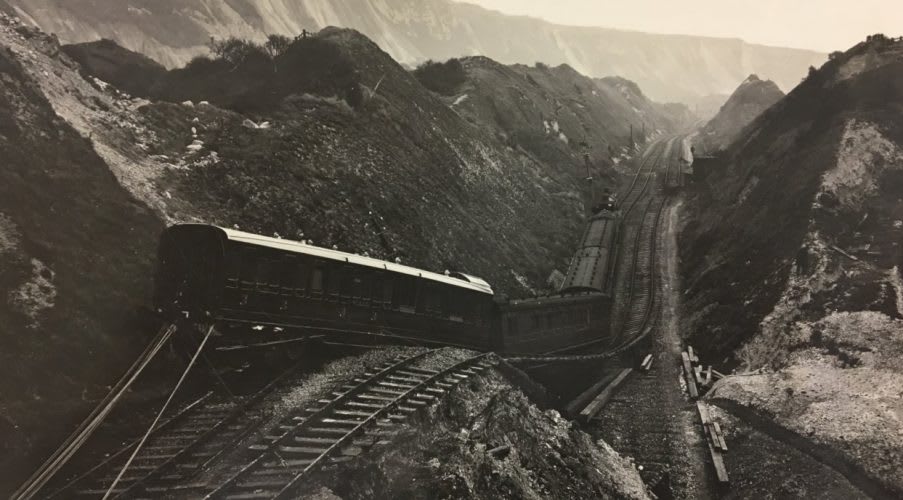
The result of the 1915 reactivation of the Folkestone Warren Landslide; image courtesy of Network Rail
Satsense analysed all of the available data from the European Space Agency’s pair of Sentinel-1 satellites (orbiting the Earth at an altitude of almost 700km, 180 degrees apart) over the area of interest in order to build up a more complete picture of the deformation.
SatSense’s proprietary algorithms processed the satellites’ data, separating horizontal and vertical motion.
The results show complex ground movement. Significant horizontal movement of the landslide is occurring at rates of up to 10mm a year. The head of the landslide is subsiding at up to 4mm a year, and the toe of the landslide is uplifting.
Network Rail was able to connect specific features identified in the SatSense results to ground-based observations.
In addition to the average velocities, SatSense was able to extract detailed time series for each data point in the image. These show that the motion of the Folkestone Warren Landslide is not steady in time.
SatSense time series are automatically kept fully up-to-date, enabling Sentinel-1 data to be used for operational monitoring of ground stability.