


A year on from the start of the development of the Digital Twin programme’s COP26 demonstrator, the project’s head Sarah Hayes reflects on what it took to develop a tool that could show technical and non-technical audiences alike the power of a digital twin.
For the United Nations Climate Conference COP26 in Glasgow last year, the National Digital Twin programme (NDTp) wanted to create an interactive demonstrator tool to help show how connected digital twins can make infrastructure more resilient to flooding due to climate change.
Part of the NDTp’s Climate Resilience Demonstrator (CReDo) project, the demonstration tool was needed to help show that more resilience is needed within existing utility systems and that collaboration and data sharing is the key to success.
Aimed at non-technical and diverse audiences, including the public, industry and government, the demonstrator could not contain real data or refer to real world locations for security/confidentiality reasons. It needed to include energy, water and telecoms networks and focus on showing the impact of extreme weather, such as flooding.
Building a fictional city
‘Creating a complex, fictitious city from scratch had never been done before, as far as we knew’
“Collaboration through connected digital twins is key to tackling climate change, but digital twins are complex to explain, particularly to non-technical audiences. We needed something visual to show during the early stages what CReDo is all about and what we are trying to achieve,” said Sarah Hayes, head of NDTp’s CReDo project. “When you’re bringing together multiple teams with different skill sets, it can be challenging to communicate effectively. The objective was to not only help connect and engage with external stakeholders, but also internal teams, to help crystallise the vision and concept of what we are producing.”
The NDTp selected Esri UK to develop an interactive demonstrator tool, following an industry-wide tender. “Creating a complex, fictitious city from scratch had never been done before, as far as we knew, but we could see Esri UK had a wealth of experience in this area and were confident it could deliver in time for COP26,” Hayes said.
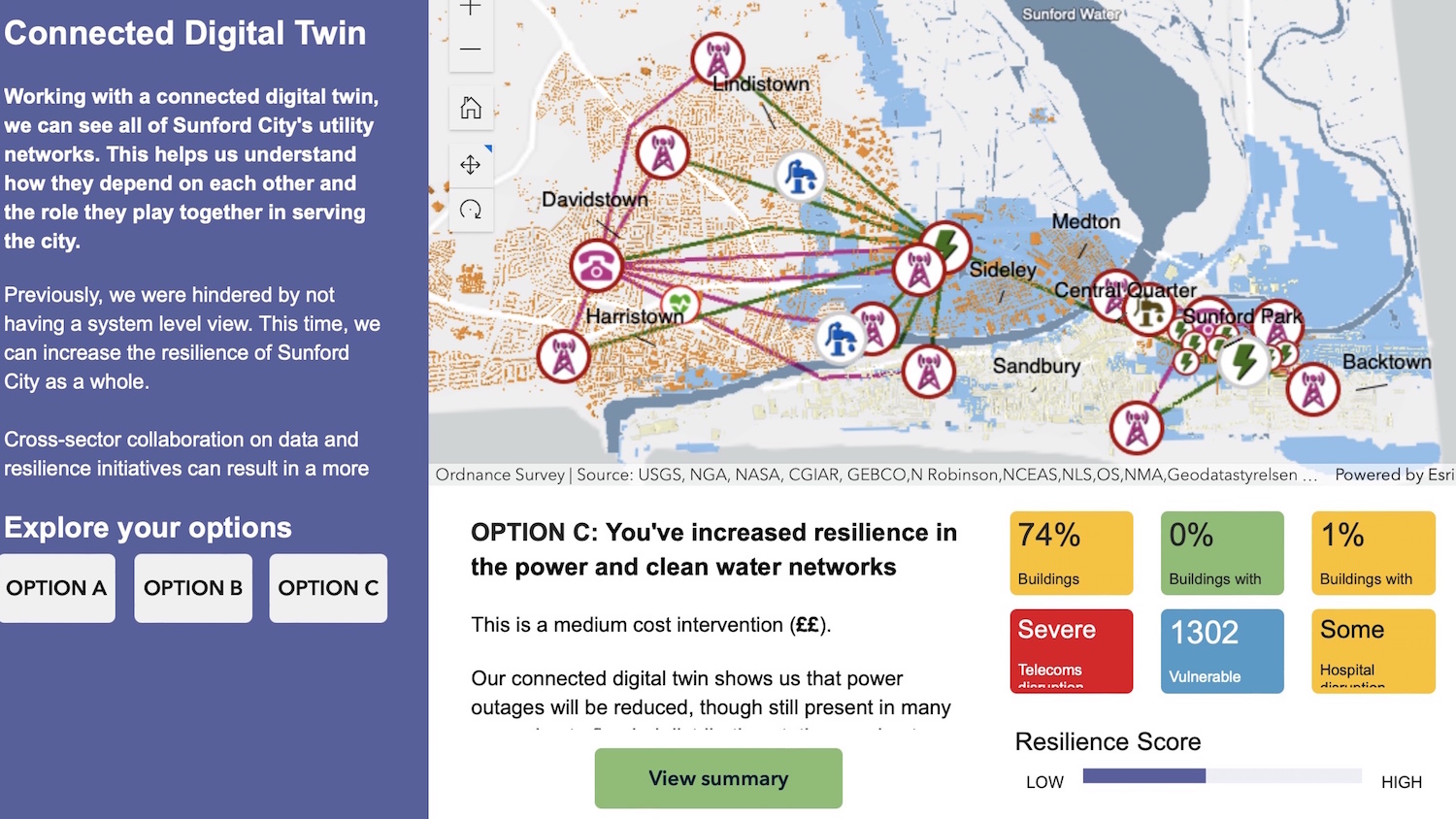
By using location as a foundation for linking disparate digital twins, Esri UK developed the tool using its GIS software. Featuring a fictional city, Sunford City, that experiences a series of severe storms and floods, the tool was designed to allow users to test different scenarios and make decisions to better protect Sunford, showing the benefits of using connected instead of isolated digital twins.
Flooding models were used to simulate how a flood would impact on Sunford City in various scenarios. Creating fabricated asset data was essential and a major part of the project’s challenge. Any interactive map couldn’t show where real assets were due to sensitivities around future flooding scenarios. “What Esri UK created in eight weeks was incredibly impressive, particularly as it was developed from scratch, but our collaborative and iterative approach gave us what we were looking for,” continued Hayes.
Assessing the impact
Not only was the project deemed a success upon launch at COP26, but it has also been used extensively by multiple partners and has played an important communication role since, as Hayes explained: “The interactive map and images have been critical in helping explain what we are trying to do and together with the short film [that was produced], helped gain support for the continuation of the CReDo project with government stakeholders and industry.
“Images taken from the demonstrator have been essential to show what kind of interventions a digital twin might consider in the future and how you would assess the impact of the interventions. The images help make the point about resilience from a system point of view, rather than a sector point of view. We needed pictures like this to get the point across quickly and easily.”
The second phase of CReDo is now continuing under Connected Places Catapult.
“Talking about something complex like a digital twin, you need a visualisation to explain the concept. The Sunford City application helped demonstrate how connecting datasets and digital twins across organisations and sectors is vital to securing future infrastructure resilience,” concluded Hayes.
Don’t miss out on BIM and digital construction news: sign up to receive the BIMplus newsletter.


