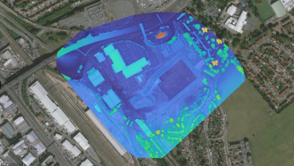
Technology Kerbside data goes digital Local authorities can access kerbside data digitally with a new partner app, AppyWay, on Esri UK’s ArcGIS platform.
Technology National Highways takes GIS route to single view of roads network National Highways staff now have a real-time view of England’s Strategic Road Network (SRN) via a single digital model.
News Met Office makes climate data more accessible The Met Office’s Climate Data Portal is now live, giving organisations improved access to climate data and other resources, and thus allowing them to better understand and respond to climate change.
News Anglian Water reduces sewer issues with real-time view of risks Anglian Water has created a real-time view of sewer risk, which is helping to drive proactive interventions to reduce sewer blockages, flooding and pollution incidents.
News Digital Construction Awards 2023 shortlist: Digital Collaboration of the Year The DCA Collaboration category recognises the best use of digitalisation/digital methodologies and/or technologies to enhance collaboration between two or more organisations on a project, at any level of the supply chain.
News Digital Construction Awards 2023 shortlist: Best Use of Data on a Project The Digital Construction Awards attracted more than 140 entries, 62 of which have been shortlisted. Here we detail the shortlist for the Best Use Of Data On A Project.
News Kier, Aecom, Everton stadium and Big Ben lead race for the Digital Construction Awards 2023 Kier, Aecom, the new Everton stadium and Big Ben lead the field of nominees for the Digital Construction Awards 2023.
Technology Hinkley Point C improves collaboration with GIS portal EDF has used enterprise GIS from Esri UK to create a geospatial portal for Hinkley Point C nuclear power station.
News Councils demonstrate role of GIS in digital planning with Esri UK Pilot projects from Nottingham City, Dacorum Borough and South Ayrshire councils have shown how GIS data can help the digital planning process with support from Esri UK.
News BIM in brief 31.01.23: smart manholes to monitor wastewater A round-up of BIM and digital construction stories that you might have missed in the past fortnight.
Technology Building the fictional city that proved the power of digital twins A year on from the start of the development of the Digital Twin programme’s COP26 demonstrator, the project’s head Sarah Hayes reflects on what it took to develop a tool that could show technical and non-technical audiences alike the power of a digital twin.
News Balfour Vinci JV uses Esri UK’s drone management to save money and de-risk work on HS2 The Balfour Beatty Vinci joint venture on the Midlands section of HS2 is saving money and has removed 800 working at risk days after successfully rolling out Esri UK’s drone flight management and image processing software.