Anglian Water has created a real-time view of sewer risk, which is helping to drive proactive interventions to reduce sewer blockages, flooding and pollution incidents.
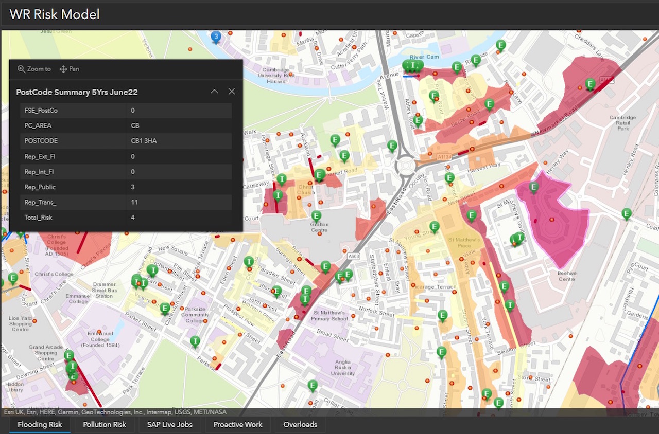
The new mapping system reveals hotspots to prioritise where work is needed across the network.
Developed using geospatial technology from Esri UK, the new risk tool has delivered the following benefits in its first six months: a 51% reduction in blockages; 112km of sewers cleaned; eight tonnes of debris removed.
A reduction in customer service issues relating to blockages has resulted in more than £1m of savings. There have also been fewer engineer call-outs, which saves time and reduces carbon emissions from unnecessary travel.
Scores that consider multiple risk factors, including sewer location, material, size, proximity to the water course and historic pollutions, are applied to sewers. The resulting dashboard shows the riskiest locations, which helps inform targeted interventions. To date, Anglian Water has used the system to find and clear more than 1,000 blockages and discover more than 1,700 structural defects, including broken pipes and tree root intrusions.
Anglian Water is the largest water and water recycling company in England and Wales by geographic area. It manages 77,000km of sewers and serves around seven million people. The new geospatial tool was developed to replace reactive and unconnected processes and systems and support better decision-making. It was designed to be used by all staff and external contractors. Since the tool’s introduction, geospatial user numbers have almost doubled.
Targeting fast-food outlets
The risk tool is continuously learning and improving, supporting additional streams of work. This includes the targeting of fast-food outlets and Anglian Water’s Keep it Clear domestic campaign to reduce blockages. Areas that are at high risk of blockages are identified, so particular food outlets or neighbourhoods can be approached and disposal methods for fats, oils and greases discussed. Network performance post intervention is then tracked in the risk tool to monitor each programme’s impact. Using the tool to work with fast food outlets has so far prevented an additional 191 blockages.
Ongoing plans include integrating flow sensor data from across the network and using the risk tool to share data and collaborate with third parties, including the Environment Agency and local authorities, when an extreme weather event occurs.
Michael Wingell, geospatial strategy manager at Anglian Water, said: “Esri GIS has allowed us to develop a holistic view of risk in real-time and shift our business model from being reactive to proactive. This new way of working helps prioritise work and investment across the network.”
Don’t miss out on BIM and digital construction news: sign up to receive the BIMplus newsletter.