


National Highways staff now have a real-time view of England’s Strategic Road Network (SRN) via a single digital model.
National Highways is using Esri UK enterprise GIS to support its Digital Roads strategy by consolidating all geospatial data and applications into one spatial portal.
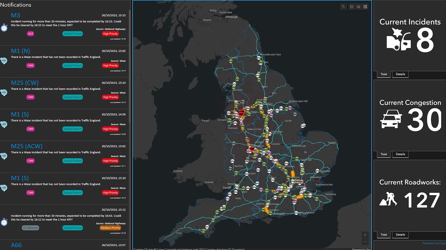
Control rooms across the country are now using a ‘single view of the network’ dashboard. This has incident alerts, details of roadworks, weather updates and the location of traffic officers available on an interactive map.
Benefits to date include being able to predict problem locations and deploy traffic officers more quickly, better coordination of roadworks to reduce disruption, and optimising traffic flows to reduce congestion and emissions.
It also removes the need to maintain multiple road models within multiple systems. Via these efficiencies, National Highways has decreased its total cost of GIS ownership by more than 10% compared with two years ago.
National Highways chief data officer Davin Crowley-Sweet said: “Our spatial data is the ‘crown jewels’ of our data landscape – the primary key of primary keys. Having a single view of it to support the whole organisation helps foster a data-driven culture, increasing business benefits and critical for delivering our Digital Roads vision and beyond.
“We are now able to react more swiftly to incidents to get traffic moving again as quickly as possible. Meanwhile, our vision for the digital roads of the future will incorporate new capabilities, such as digital twins, predictive planning, single view of assets, and connected autonomous vehicles. Each of these initiatives will require a common, trusted representation of the network to be successful.”
Spatial data in the SRN model includes information on more than 4,000 miles of roads, bridges, tunnels and other assets, including road signs and cameras.
Data worth £60bn
National Highways made the move to an Esri enterprise GIS more than a year ago, following recognition that geospatial data was its most critical type of data. This was the result of an in-depth asset evaluation that valued its data overall at £60bn. Delivered via Esri UK’s managed cloud service, the GIS consolidates all location data into one central system and provides a wide range of applications, data models and other GIS services, enabling 5,660 staff to make better use of spatial data.
“National Highways is at the forefront of demonstrating what a true enterprise GIS can achieve,” said Chris Barber, head of transport at Esri UK. “Esri technology is helping to maximise the value gained from geospatial data, which is now used more extensively across the organisation.
“Taking an enterprise approach gives National Highways a solid, scalable foundation to help meet its Digital Roads objectives and tackle some of the most pressing challenges facing our roads today and in years to come.”
National Highways won an Esri Special Achievement in GIS Award for its work at the recent Esri annual user conference in California. More than 100,000 entries were submitted for the awards.
Don’t miss out on BIM and digital construction news: sign up to receive the BIMplus newsletter.


