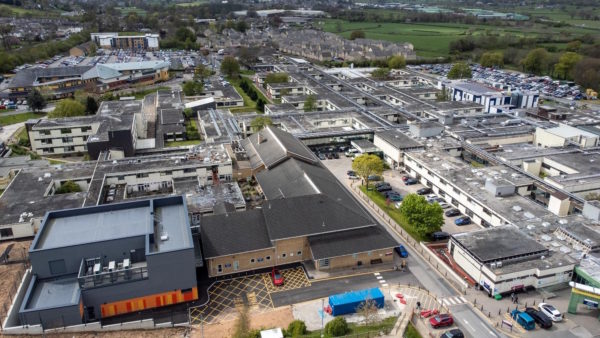
The Estates Team at the Royal Holloway, University of London (RHUL) has numerous infrastructure and improvement projects underway. Although the university already has a large volume of asset data – as-built drawings, floor plans, and tree and garden information – each has varying levels of quality, positional accuracy, and age.
RHUL hired LandScope Engineering to undertake an integrated PAS 128:2014 utility mapping and topographical survey of the entire campus and provide a single view of all the campus assets, both above ground and below ground. RHUL realised that the best way to house and share this information was by creating a digital twin.
The challenge
LandScope needed to find a solution that could incorporate its multi-discipline survey data sets, including traditional survey strings, point cloud and metadata, in addition to campus legacy data. With such a large volume of data, however, it was increasingly difficult to display it in traditional survey packages.
LandScope was unable to display its more sophisticated data sets in RHUL’s geospatial information system (GIS). Additionally, the university’s legacy data was stored separately across different departments, making it very difficult to access and share. For example, locating chambers on a drawing and locating the metadata for maintenance holes took approximately one hour per 50 maintenance holes. When a client wanted to view the utility mapping drawing and the associated maintenance hole metadata, they had to search through numerous folders and cross-reference each to find the relevant information. With more than 1,600 maintenance holes across the campus, this process took significant time and was costly, making it highly inefficient.
The breakthrough
Given the scale of the campus, LandScope decided to incorporate mobile survey solutions. It began by capturing 360-degree site-wide images by deploying a Topcon IP-S3 mobile mapping system and unmanned aerial vehicle for high-resolution photography. It also used mobile ground-penetrating radar to simultaneously capture data below the ground. This data was matched to the mobile mapping data for full coverage from the ground level, as well as from above to capture a complete building data set.
After researching for solutions that could display a large amount of multidiscipline data in one place as a digital twin, LandScope chose Orbit 3DM to create a single view of the data. The Orbit 3DM plug-in capabilities meant that both GIS data sets could run seamlessly alongside each other without creating duplicate systems. The application allowed all users to perform quick search queries, which was a near-impossible task prior to implementing the software.
As a result, field teams could record inspection chamber metadata – including invert levels, pipe diameters, and photography – directly into the application on their tablets and mobile devices. Photographic records included traditional and 360-degree chamber images. The application allows the maintenance hole data and images to be viewed with either GIS or augmented reality.
“Orbit GT provides a central database for asset information based on its geographical location. All survey formats (point cloud, photography, line work, and metadata) can be brought together and displayed in a single environment, rather than needing multiple specialist packages. This ensures data is easy to locate and asset data can be simply accessed by clicking on the item of interest,” said Mark White, geoscience manager at LandScope. “Furthermore, Orbit server- and cloud-based solutions allow all stakeholders to have simple, easy access to asset information without needing to install specialist software.”
The outcome
Now, each university department is responsible for continually updating the system. LandScope can survey any new asset or infrastructure as a standard to ensure that the database is always current.
This digital twin provided a single view of above-ground and below-ground assets, improving stakeholder collaboration and reducing duplication of work and operational costs. The 3D models of proposed infrastructure projects are incorporated into this digital environment. Now, stakeholders can visualise future developments in the context of the existing campus. Furthermore, students can experience campus life through virtual campus tours rather than physically visiting the site.
Image: a screen grab of RHUL’s assets in Orbit 3DM.