


Drone pilots at Sellafield have successfully completed two significant test flights to 3D map and test radiation levels during the site’s decommissioning.
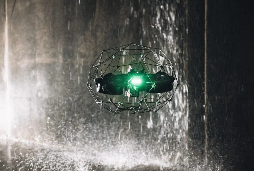
The successful deployment of the Flyability Elios 3 drone equipped with a LiDAR sensor for mapping and 3D modelling marks a major milestone for the unmanned aerial vehicle (UAV) team at Sellafield Ltd.
Amanda Smith, UAV equipment programme lead at Sellafield, said: “We’re thrilled that this first flight of Elios 3 with the LiDAR payload was a success. The data collected is now being processed in a CAD system, which will produce a 3D model of the area in question, helping to inform engineering decisions going forwards.
“Sending a drone into this tight and unused space, rather than an employee in the first instance, reduces risk and also saves time and money.
“The team put a lot of work into making sure they were fully prepared for this flight. There are building plans they can study and try to work out the best route for the drone to take."
Pressure test
Sam Jay, UAV equipment engineer and chief pilot at Sellafield, added: “The flights can be very intense, and in this case, there was pipework everywhere. The drones fly in a cage with sensors, so if they do happen to touch anything, they won’t be damaged.
“The hardest part is remembering your way out again. In such a short space of time, you need to get in and out quickly. There can be a lot of pressure as not getting the drone out and having to send someone in after it would defeat the point of the flight.”
The Elios 3 is distinguished by its wrap-around cage: Flyability describes it as "collision-tolerant".
It comes with an Ouster OS0-32 LiDAR sensor, allowing inspectors to collect data for the creation of survey-grade 3D models using software from Flyability’s partner, GeoSLAM. The technology turns the drone’s LiDAR data into 3D models in real time, while the drone is in flight.
Hot on the heels of the first flight, the Sellafield UAV team then successfully flew the Elios 3 drone with a radiation activity detection dosimeter. They hope this will allow them to map radiation hotspots in areas before other colleagues go into unused areas of the Sellafield site.
Don’t miss out on BIM and digital construction news: sign up to receive the BIMplus newsletter.


