


The Geospatial Commission is seeking industry input on how the access to and use of the National Underground Asset Register data can be expanded.
The Geospatial Commission launched the first phase of the digital map of underground infrastructure in spring 2023 in London, the North East and Wales. The minimum viable product of the National Underground Asset Register (NUAR) is now live in the South East, South West, North West, Yorkshire and the Humber, and East of England as well.
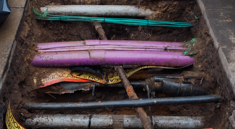
NUAR includes data from all of the major energy and water providers, including Welsh Water, Cadent Gas and UK Power Networks, several major telecommunications companies, including CityFibre and Virgin Media O2, as well as smaller providers of such services, transport organisations and local authorities.
Initially, NUAR has been made available to underground asset owners and their supply chain to support the ‘safe dig’ use case.
The new discovery project, part-funded by the Government Office for Technology Transfer, will explore the potential benefits of widening access to NUAR and the constraints surrounding new propositions.
The Geospatial Commission believes potential opportunities include making NUAR:
- available to other user groups for safe digging purposes, such as landowners and developers;
- available to support other use cases (e.g. electric vehicle charge point roll-out, flood risk planning, emergency response, conveyancing, property development, etc.) ; and
- accessible via third-party intermediaries/APIs rather than solely via the NUAR user interface.
“However, these opportunities do not come without constraints and risks,” said Richard Duffield, NUAR discovery project lead. “Our discovery work aims to assess both the feasibility and value of such opportunities, with only the ideas that prove to be truly feasible and have the support of our asset owner community and national security stakeholders taken forward in future years.”
More than safe digging
He revealed that since the inception of NUAR, “we have regularly been contacted by individuals and organisations interested in accessing NUAR data for purposes beyond the ‘safe dig’ use case currently permitted”.
He added: “We have also been contacted by several data service providers, asking how they can support asset owners in ensuring NUAR data is used in as many excavations as possible.”
Starting in spring 2024, the Geospatial Commission will run a series of half-day in-person workshops to explore potential future uses in more detail. Interested parties can email [email protected] with any ideas they would like the discovery project to explore.
“Suggestions could span the areas of planning and design, asset management and maintenance, strategic planning, innovation or something else altogether,” said Duffield.
Don’t miss out on BIM and digital construction news: sign up to receive the BIMplus newsletter.


