


The National Underground Asset Register (NUAR) is now available across the whole of England and Wales.
The Geospatial Commission launched the first phase of the digital map of underground infrastructure in the spring in London, the North East and Wales. The minimum viable product (MVP) of NUAR is now live in the South East, South West, North West, Yorkshire and the Humber, and East of England as well.
NUAR includes data from all of the major energy and water providers, including Welsh Water, Cadent Gas and UK Power Networks, several major telecommunications companies, including CityFibre and Virgin Media O2, as well as smaller providers of such services, transport organisations and local authorities.
Designed in collaboration with those who will use it, the interactive digital map gives planners and excavators standardised, secure access to the data they need, when they need it, to carry out their work effectively and safely, according to the Geospatial Commission.
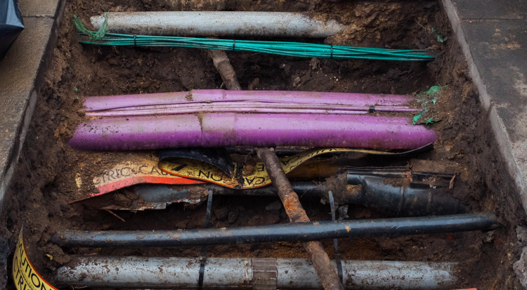
It is estimated there are around 4 million km of buried pipes and cables in the UK. A hole is dug every seven seconds to install, fix, maintain or repair those assets. Approximately one in every 65 holes dug results in an accidental asset strike (approximately 60,000 a year). This results in around £2.4bn worth of economic cost, puts workers’ lives at risk, and causes disruption.
Digging a hole
The Geospatial Commission estimates that NUAR will deliver £490m a year of economic growth through:
- increased efficiencies in construction and development;
- less accidental damage to pipes and cables;
- reduced disruption to the public and businesses (from extended road closures and congestion);
- and improved worker safety.
The Commission will expand the coverage of the MVP version of NUAR to Northern Ireland by spring 2024. Through iterative development, the platform will be fully operational across the three nations by the end of 2025.
Furthermore, the government tabled measures in Parliament this week (Wednesday 22 November) to update existing legislation. This will enable the Geospatial Commission to take advantage of opportunities provided by data and technology advancements to simplify and expedite the process by which underground asset data is shared.
The Commission said these updates will reduce the time taken for workers to get all the data they need from six days to 60 seconds.
Scotland already benefits from a system of this kind (Scottish Community Apparatus Data Vault). Scottish government officials have helped inform the development of NUAR, ensuring consistency across the two services.
Don’t miss out on BIM and digital construction news: sign up to receive the BIMplus newsletter.


