


Developer Vastint UK and consultant Bryden Wood have developed a site-wide model of a 26-acre waterside development near Stratford, east London. The digital project is claimed to be the largest and most complex BIM project ever undertaken by the tech-led design company.
Bryden Wood is the executive architect and chief engineer for the phased scheme Sugar House Island and is using BIM to provide a single, site-wide, collaborative 3D design environment for the entire project.
To introduce variation to the look and feel of the Island’s eight buildings, Vastint UK has employed nine architect and design companies across the project, including both established and up-and-coming practices in both the UK and Europe. The model brings together the design work of these different practices into a single platform
The model incorporates the design and construction of 1.2km of new river wall, the remediation and cut and fill of soils, the design and installation of infrastructure as well as the design of all buildings and surrounding landscape.
“We’re pushing the use of BIM well beyond visualisation to achieve design standardisation and unprecedented levels of collaboration between all partners involved in this project,” says Ionut Hapaianu, director at Bryden Wood.
The BIM models, particularly the river wall model, proved effective in reducing problems when BWT had to design and locate piles for the new buildings. Also, by creating a BIM model of all old piles left from previous buildings, BWT has helped to avoid serious clashes with new buildings piles and potential clashes of MEP pipework across the site.
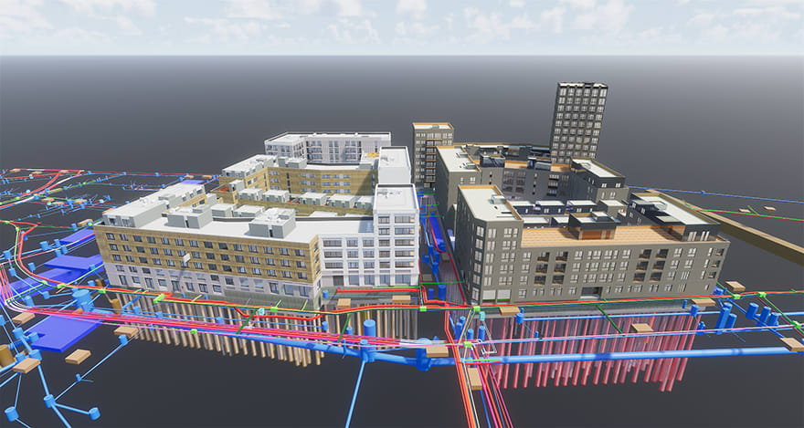
The BIM models proved effective in reducing problems when BWT had to design and locate piles for the new buildings.
Bryden Wood first started working on the scheme with the developer three years ago, when it was decided to commission a full BIM model of the site at the outset because of its complexity and scale.
“It was soon clear that it would be an invaluable tool. We have been able to use it for both design and procurement output,” explains Hapaianu.
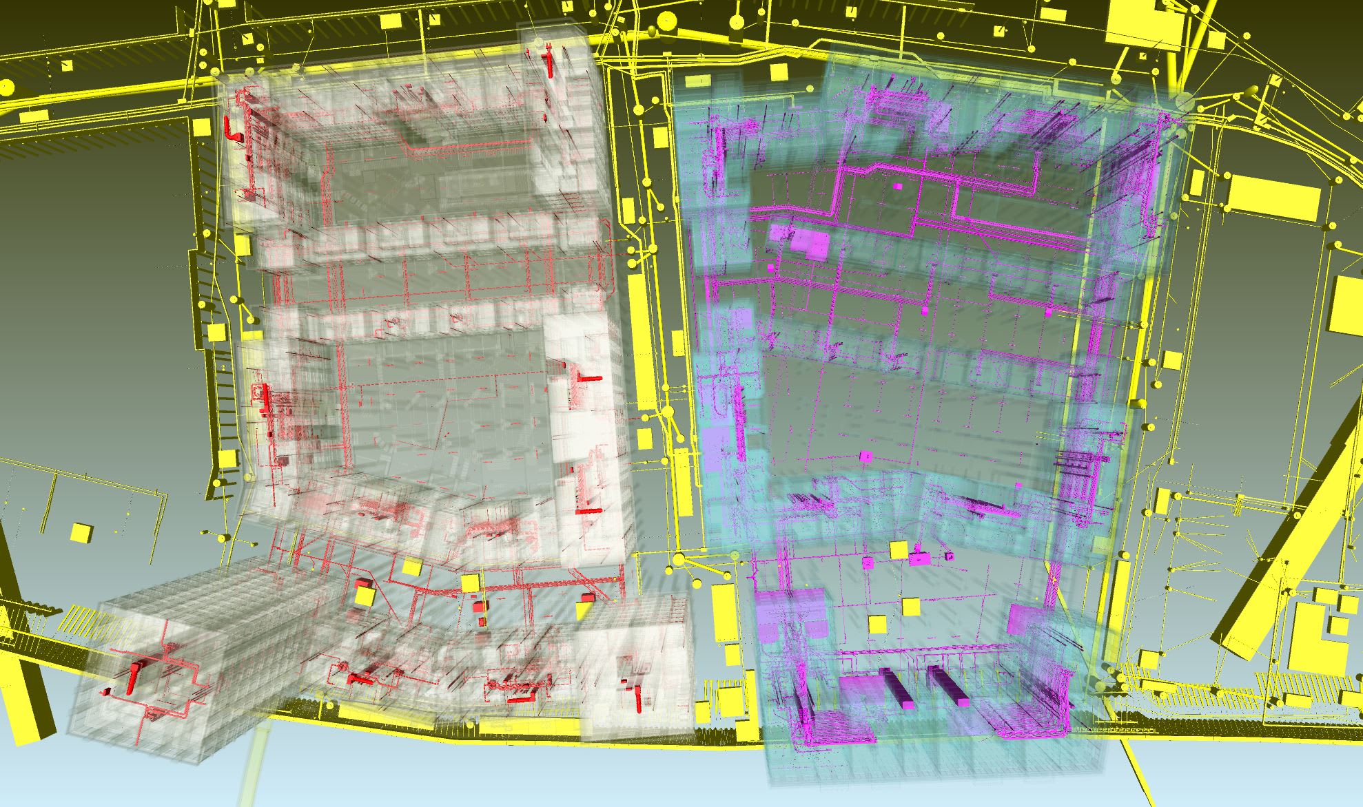
“Design teams were brought together for regular site-wide coordination meetings and were given set standardisation rules teams for each plot had to follow. Each ‘plot’ team designed on their own information and BIM models up to construction stages, but the information was brought together in the overarching site model since early stages so that clashes could be spotted and avoided in construction.
“Because all the teams had followed the same rules for creating a common data environment, the models were able to be brought together in this way.
“What’s more it has also helped the client visualise the concept of the scheme.
Michiel van Soest, development manager & head of projects at Vastint UK, says: “Teams have used it to communicate across disciplines and it has definitely de-risked the project for our contractors. The outputs have even been used by the marketing team to enable agents and purchasers to take 3D tours through a simulation of the finished scheme. We now plan on rolling out this technology across our Leeds and Cardiff sites.”
The Sugar House Island BIM has been created in Revit (and IFC files from other software/other consultants) and is used with Navisworks.
The use of BIM gives the scheme’s plot designers (many of whom are working in 2D) the ability to see their work in 3D context and to “zoom in” on detailed elements. This aids visualisation, solves coordination issues, helps design teams and Vastint to understand complexity, and solves issues. It also helps the designers to understand whether a certain interface works with the surrounding landscape, for example.
Much more than simply clash detection, the project takes BIM another step closer to its future use by taking the information linked to and generated by the models to standardise major design aspects across the site.
An integrated design system has been created where total construction IP is shared between Vastint, Bryden Wood, plot architects, landscape design teams, infrastructure and construction partners and contractors.
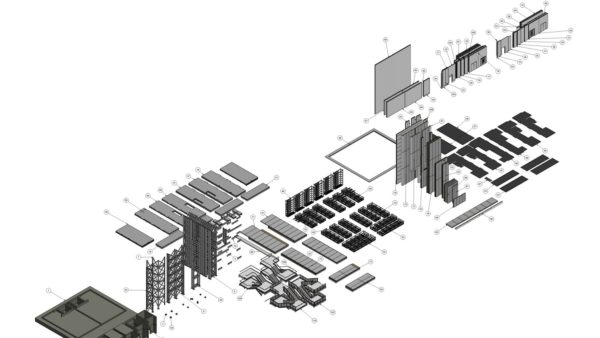
To refine and blend design as much as possible, and allow the effective use of standardised solutions, Bryden Wood has produced a design guide for plot architects to drive efficiencies and retain consistent quality.
Within these design guidelines, connections and interfaces can be standardised and many components are repeatable. These components can be produced in high volumes, creating a consistent pipeline with economies of scale, as well as more dependable and timely supply.
Working with advanced BIM also enables major design changes to be made with relative ease.
Hapaianu continues: “It’s a good way of managing and understanding change because you can retain previous design models and compare and contrast a variety of options until you arrive at the best possible solution.”
The project’s BIM is an example of Bryden Wood’s commitment to technology-enabled, automated construction to drive efficiency and increase productivity.
The Sugar House Island BIM has been created in Revit (and IFC files from other software/other consultants) and is used with Navisworks.
Sugar House Island is currently under construction and leasing offices, with residential on sale from 2019.
Dane’s Yard is the first phase of the project to go live and is designed by masterplanner ARC-ML, design architect Waugh Thistleton Architects (WTA), and landscape architect Planit-IE.
At technical design stage, the use of BIM was widened to include the river wall designed by Dutch company Van ‘t Hek, and infrastructure designed by PBA and Vital Energi; incorporating data from MEP engineer PBA and structural designer eHRW under the coordination of WTA and Bryden Wood.
It enabled the team to undertake effective upfront design coordination and clash detection. Contractors, including JF Hunt for infrastructure, are feeding as-built information into the model as construction is progressing.
Images: Bryden Wood
Sugar House Island
Sugar House Island is a mixed-used site in East London. It includes:
- 26-acre (10-hectare) development bounded by water near the Olympic Park in east London.
- 624,000ft² (58,000m²) offices bringing 2,500 jobs to the area; with the first phase, Dane’s Yard, offering 100,000ft² (9,000m²) to the creative industries.
- 1,200 homes, with 40% 3-bed or more.
- 3 acres (1.2 hectares) of open space including gardens, yards and a new riverside park.
- Restaurants, cafés and shops.
- Planning consent for a two-form entry primary school.
- A 350-bed hotel.
- 3 new bridges connecting the development into surrounding communities.
- 1.2km of river wall replaced, with a 100-year design life, as part of the development’s long-term vision.
Comments
Comments are closed.


BIM is also being used to coordinate the 26 Ha Queens Wharf project in Brisbane, Australia:
https://queenswharfbrisbane.com.au/